Afsluitdijk voor de Middellandse Zee: Atlantropa voor energie en land
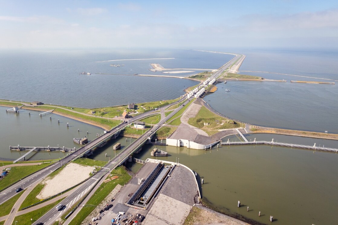
Woestijnen inunderen, het klimaat veranderen en de kustlijn van hele continenten opnieuw intekenen. Gedurende een groot deel van de 20e eeuw meende de mens de planeet naar eigen goeddunken te kunnen herinrichten. Hoogmoedswaanzin, zeggen we met de wijsheid van nu. Maar als je de Zuiderzee kunt indammen, waarom dan niet hetzelfde doen met de Middellandse Zee?

Tekst: Fanta Voogd. Beeld: Ittiz (openingsillustratie), Herman Sörgel, ANP / Hollandse Hoogte / CAMJO media / Jaring Rispen (Afsluitdijk)
In de herfst van 1927 begon de Beierse architect Herman Sörgel met het ontwikkelen van zijn ideeën voor wat hij aanvankelijk Panropa noemde. In 1932 publiceerde Sörgel een boek over zijn plannen. In die sombere jaren tussen twee wereldoorlogen werd zijn visioen welwillend tot geestdriftig ontvangen. Panropa had hij inmiddels herdoopt in Atlantropa.
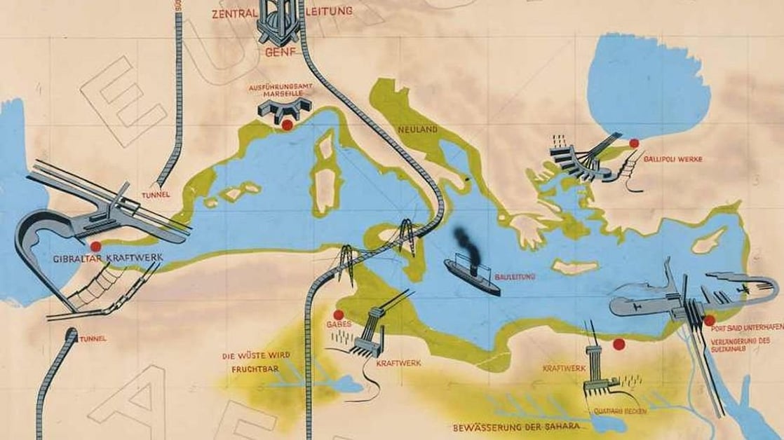
De kern van het Atlantropa-project vormt een 29 kilometer lange stuwdam tussen het Spaanse stadje Tarifa en de Marokkaanse stad Tanger. Het plan was gebaseerd op de destijds pas ontdekte eigenaardigheid dat er op de Middellandse Zee zo veel water verdampt dat er elke seconde 88.000 kubieke meter door de Straat van Gibraltar oostwaarts stroomt. Die stuwdam en een kleinere versie in de Turkse Dardanellen konden een gigantische hoeveelheid elektriciteit opwekken.
Droogvallen Adriatische Zee
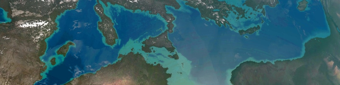
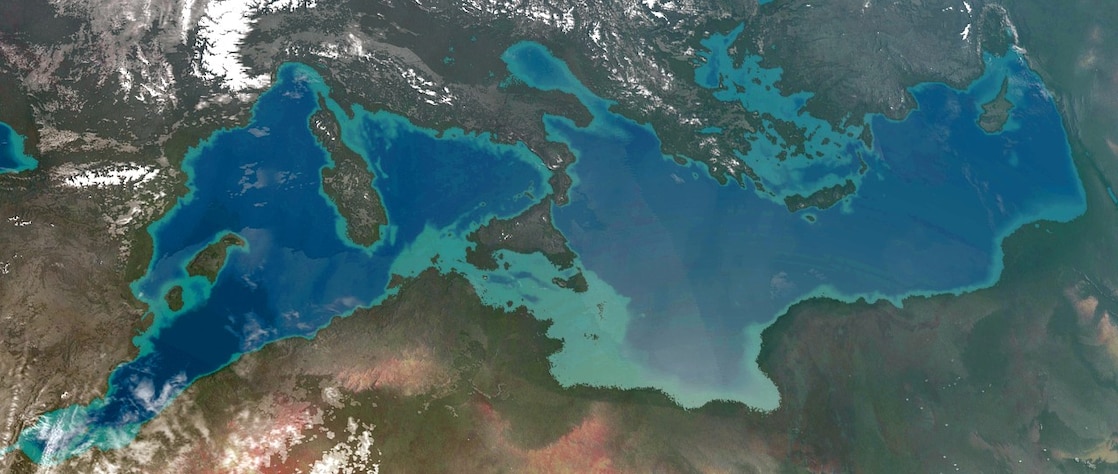
Zeker zo belangrijk als de energieopwekking was dat het niveau van de Middellandse Zee met de beoogde afdamming uiteindelijk tot 200 meter zou dalen. Daardoor zou een totale landwinst ter grootte van Spanje worden gerealiseerd. De Adriatische Zee zou grotendeels droogvallen. Met Venetië dacht Sörgel het goedgemaakt te hebben: daar moest een kunstmatig waterbassin uitkomst bieden. Maar de havensteden Marseille, Genua en Thessaloniki kwamen met Sörgels plan tientallen kilometers landinwaarts te liggen.
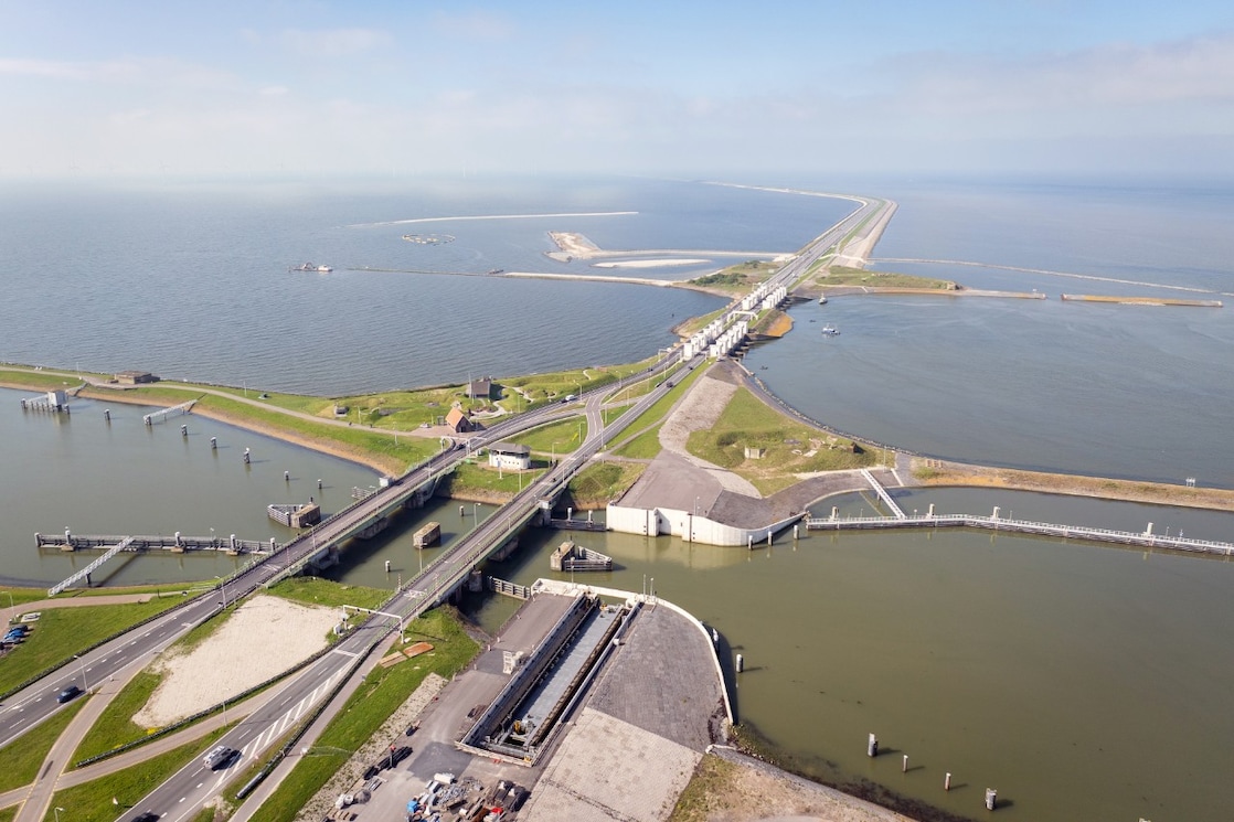
Het project zou echter zo veel elektriciteit en nieuwe vruchtbare landbouwgrond opleveren dat de noodzakelijke verplaatsing van de havensteden, de verlenging van het Suezkanaal en de enorme sluizencomplexen voor de verbinding met de Atlantische Oceaan probleemloos te bekostigen zouden zijn. Om de haalbaarheid van zijn plan te onderstrepen verwees Sörgel voortdurend naar de Nederlandse ingenieur Cornelis Lely en “zijn” Zuiderzeewerken.
Meer Geschiedenis van de toekomst
Dit verhaal is deel van de Geschiedenis van de toekomst, een serie verhalen los verbonden met de wereld van energie geschreven door freelance journalist Fanta Voogd.
Lees ook:
‘Witte steenkool’
Sörgel werd vooral gedreven door de vrees dat Europa zou worden overvleugeld door het zich snel ontwikkelende 'Pan-Azië' en 'Pan-Amerika'. Om die economische dreiging het hoofd te bieden moesten de Europese landen zich niet alleen verenigen, maar ook samenvloeien met Afrika. In zijn lezingen en geschriften hamerde Sörgel op de dreigende uitputting van de Europese steenkool- en aardoliereserves, en de mogelijkheden van waterkracht ('witte steenkool'). Dat maakt hem niet alleen tot een vroege pleitbezorger van de Europese eenwording, maar ook van de energietransitie.
Onderdeel van het Atlantropa-project was een spoortraject van Parijs via de dam over de Straat van Gibraltar naar Marokko, en een traject van Berlijn via Rome naar Tunesië — via een dam vanaf Sicilië dat volgens Sörgels berekening in zijn plan aan het Italiaanse vasteland zou zijn vastgegroeid. Dankzij die verbindingen konden de nog onontgonnen vruchtbare gronden en de natuurlijke rijkdommen van Afrika beter worden benut. Nog radicaler waren Sörgels plannen om de Kongo-rivier af te dammen en een groot deel van het Afrikaanse binnenland om te toveren in twee onmetelijke binnenzeeën.
Koloniale wensen
Sörgels plannen met Afrika waren doortrokken van de heersende koloniale superioriteitswaan. Hoewel hij als pacifist, aan Bauhaus gelieerde architect en vroege aanhanger van de Europese gedachte beslist geen nationaalsocialist was, werd zijn project wel gekleurd door de Duitse fixatie op Lebensraum en de vrees voor Der Untergang des Abendlandes.
Het naziregime, geobsedeerd door gebiedsuitbreiding naar het oosten, had geen interesse in Sörgels zuidelijk georiënteerde plannen en legde hem zelfs een publicatieverbod op. Na de Tweede Wereldoorlog blies Sörgel zijn Atlantropa-Institut nieuw leven in. Kerstmis 1952 vond hij echter de dood toen hij door een auto van zijn fiets werd gereden. Daarmee kwam ook aan zijn project een einde.
Atlantropa-plan, 1932Nog radicaler waren Sörgels plannen om de Kongo-rivier af te dammen
Maatschappelijke ontwrichting
Wie nog eens goed naar Sörgels plannen kijkt, ziet al snel de grote nadelige gevolgen. Allereerst hebben de ingrijpende wijziging van de mediterrane kustlijn en het inunderen van een groot deel van Afrika een onacceptabele maatschappelijke ontwrichting tot gevolg. De ecologische effecten zijn enorm. Denk aan de verandering van het zoutgehalte in de verkleinde Middellandse Zee of aan de onvermijdelijke verhoging van het waterpeil in de overige wereldzeeën. De ingreep zou een niet te overzien effect hebben op de golfstromen en het klimaat. De immense vermindering van de druk op de instabiele aardkorst in het Middellandse Zeegebied zou bovendien totaal onvoorspelbare vulkanische en seismische gevolgen kunnen hebben.
Noordzeepolder
Maar de plannenmakerij van Sörgel is beslist niet af te doen als de fantasie van een extravagante eenling. Gigantische waterbouwkundige projecten als de Aswan-dam (1899-1970) en de Zuiderzeewerken (1920-1975) zijn vruchten van dezelfde tijdsgeest, die op hun beurt inspireerden tot nog ambitieuzere projecten.
Zo publiceerde het weekblad Het Leven – Geïllustreerd in 1929 over het geheimzinnige idee uit de 'Duitsche ingenieurswereld' om de Noordzee tussen Engeland en Jutland in het noorden en tussen Dover en Calais in het zuiden af te dammen en in te polderen. In de Sovjet-Unie werkte men vanaf 1933 aan het plan de loop van grote Siberische rivieren om te keren. Na de oorlog maakten Sovjet-wetenschappers plannen het Siberische klimaat te beïnvloeden door met dammen de golfstromen op de Grote Oceaan om te buigen. Later is er serieus nagedacht over de afdamming van de Beringstraat tussen Siberië en Alaska.
Omslag vanaf 1970
Vanaf 1970 is er een omslag gekomen in het denken over de mensheid en haar plaats op de planeet. Het eeuwige besef dat de mens zich staande moet zien te houden in een vijandige natuur maakte plaats voor het besef dat je de natuur maar beter te vriend kunt houden. In Nederland leidde dat tot een nieuwe kijk op waterbeheer en een subtielere aanpak dan de aloude ‘strijd tegen het water’. Dat begon met de stormvloedkering in de Oosterschelde (vanaf 1976) en kreeg een vervolg in het zogeheten integraal waterbeheer, dat - onder met motto 'ruimte voor water' — de zorg om de veiligheid en de natuur laat samenvallen. En net als in de tijd van Leeghwater en Lely geldt dit nieuwe waterbeheer als een succesvol exportproduct.
.De Zuiderzeewerken zijn vruchten van dezelfde tijdsgeest
Closing of the Mediterranean Sea: Atlantropa for energy and land
23 Sep 2026
Flooding deserts, altering the climate, and redrawing the coastlines of entire continents. For much of the 20th century, humanity believed it could reshape the planet at will. With the benefit of hindsight, we recognise this as an extraordinary act of hubris. Yet if it was possible to tame the Zuiderzee, why not attempt the same with the Mediterranean Sea?

Text: Fanta Voogd. Imagery: Ittiz (featured image), Herman Sörgel, ANP / Hollandse Hoogte / CAMJO media / Jaring Rispen (Afsluitdijk, the Netherlands)
In the autumn of 1927, the Bavarian architect Herman Sörgel began developing his ideas for what he initially called Panropa. In 1932, Sörgel published a book outlining his plans. In those bleak years between the two world wars, his vision was received with anything from cautious approval to outright enthusiasm. By then, he had renamed Panropa as Atlantropa.
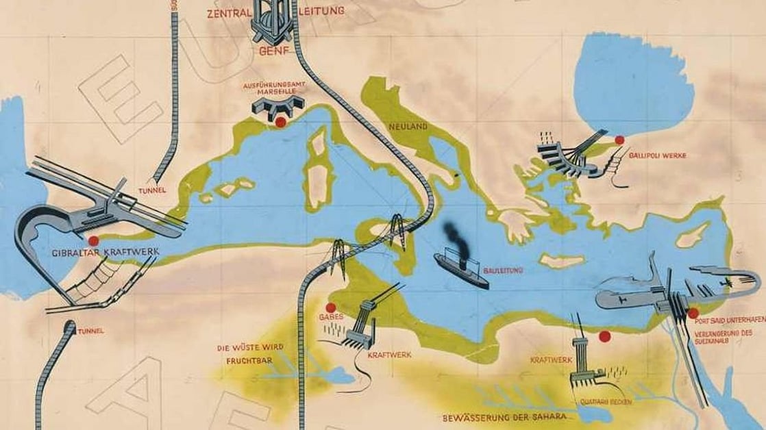
At the heart of the Atlantropa project was a 29-kilometre-long (18-miles-long) dam stretching between the Spanish town of Tarifa and the Moroccan city of Tangier. The scheme was based on the recently discovered phenomenon that so much water evaporates from the Mediterranean Sea that 88,000 cubic metres flow eastwards through the Strait of Gibraltar every second. This dam, together with a smaller version in the Turkish Dardanelles, would have generated an enormous amount of electricity.
The disappearance of the Adriatic Sea
Energy production was only part of the ambition. Equally important was the expectation that the level of the Mediterranean Sea would eventually fall by as much as 200 metres (656 feet) as a result of the proposed barrier. This would create an area of new land equivalent in size to Spain. Much of the Adriatic Sea would dry up. Sörgel believed he had solved the problem for Venice by proposing an artificial lagoon. Other port cities, however, including Marseille, Genoa and Thessaloniki, would have found themselves dozens of kilometres/miles inland under his plan.
Nonetheless, the project was expected to generate so much electricity and so much fertile agricultural land that the relocation of port cities, the extension of the Suez Canal and the construction of vast lock complexes linking the Mediterranean to the Atlantic could all be financed without difficulty. To demonstrate the feasibility of his vision, Sörgel repeatedly pointed to the achievements of the Dutch engineer Cornelis Lely and his Zuiderzee Works.
‘White coal’
Sörgel was driven above all by the fear that Europe would be eclipsed by the rapidly developing worlds of ‘Pan-Asia’ and ‘Pan-America’. To counter this economic threat, he believed that the countries of Europe should not only unite but also merge with Africa. In his lectures and writings, Sörgel repeatedly warned of the impending depletion of Europe’s coal and oil reserves, while championing the potential of hydropower, which he referred to as ‘white coal’. This makes him not only an early advocate of European integration, but also a precursor of the energy transition.
Part of the Atlantropa project involved a railway line running from Paris, across the dam spanning the Strait of Gibraltar, to Morocco. Another would link Berlin and Tunis via Rome and a dam extending from Sicily, which, according to Sörgel’s calculations, would eventually become connected to the Italian mainland as sea levels fell. These transport links would allow the fertile but largely undeveloped lands and natural resources of Africa to be exploited more effectively. More radical still were Sörgel’s plans to dam the Congo River and transform large parts of Africa’s interior into two vast inland seas.
Colonial ambitions
Sörgel’s vision for Africa was deeply shaped by the colonial attitudes and assumptions of superiority that prevailed at the time. Although he was a pacifist, an architect associated with the Bauhaus movement, and an early supporter of the European ideal rather than a National Socialist, his project nevertheless reflected contemporary German preoccupations with Lebensraum and fears of Der Untergang des Abendlandes (The Decline of the West).
The Nazi regime, obsessed with territorial expansion towards the east, showed little interest in Sörgel’s southward-looking plans and even imposed a publishing ban on him. After the Second World War, Sörgel revived his Atlantropa Institute and resumed promoting the project. However, on Christmas Day 1952, he was killed when a car struck him while he was cycling. With his death, the Atlantropa project effectively came to an end.
Societal Disruption
Anyone taking a closer look at Sörgel’s plans quickly becomes aware of their profound drawbacks. First and foremost, the drastic reshaping of the Mediterranean coastline and the inundation of vast areas of Africa would have caused unacceptable social upheaval. The ecological consequences would have been enormous. Consider, for example, the changes in salinity within the reduced Mediterranean Sea, or the inevitable rise in sea levels elsewhere in the world’s oceans. Such an intervention would have had incalculable effects on ocean currents and the global climate. Moreover, the immense reduction in pressure on the unstable earth’s crust beneath the Mediterranean basin could have triggered entirely unpredictable volcanic and seismic activity.
A North Sea Polder
Yet Sörgel’s grand designs should not simply be dismissed as the fantasy of an eccentric visionary. Mega-engineering projects such as the Aswan Dam (1899-1970) and the Zuiderzee Works (1920-1975) were products of the same mindset, and in turn inspired even more ambitious proposals.
In 1929, for example, the Dutch weekly magazine Het Leven – Geïllustreerd reported on a remarkable idea emerging from the “German engineering world”: to dam and reclaim the North Sea by constructing barriers between England and Jutland (Denmark) in the north and between Dover (United Kingdom) and Calais (France) in the south. In the Soviet Union, plans were developed from 1933 onwards to divert the courses of major Siberian rivers. After the war, Soviet scientists proposed influencing the Siberian climate by redirecting Pacific Ocean currents through the construction of dams. Later, serious consideration was even given to damming the Bering Strait between Siberia and Alaska.
A shift in thinking after 1970
From around 1970 onwards, attitudes towards humanity’s place on the planet began to change. The age-old belief that humankind must constantly battle a hostile natural world gave way to a growing recognition that it was wiser to work with nature rather than against it. In the Netherlands, this led to a new philosophy of water management and a more nuanced approach than the traditional ‘battle against the water’.
The transition began with the Eastern Scheldt (Oosterschelde) storm surge barrier in Zeeland in the southwest of the Netherlands from 1976 onwards, and continued through the development of integrated water management. Under the motto of “making room for water”, this approach seeks to combine flood protection with the preservation and enhancement of nature. And, just as in the eras of Leeghwater and Lely, this modern approach to water management has itself become a successful Dutch export product.